Monthly Archives: November 2024

Day 4.  Tongariro Northern Circuit.

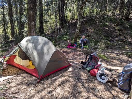
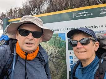
We had a much quieter night in our lovely campsite under the trees and woke to another sun filled day.  We packed up camp, had our usual porridge and coffee, and were on our way by 7.15.

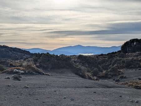
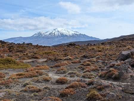
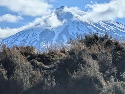
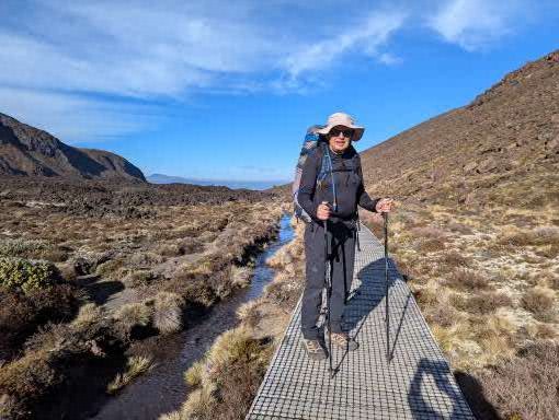
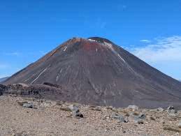
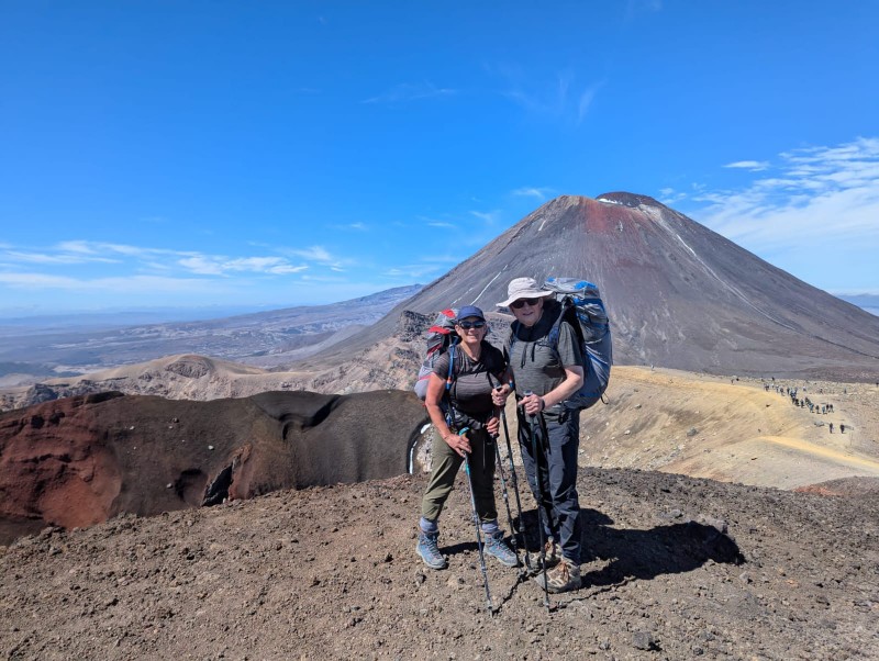
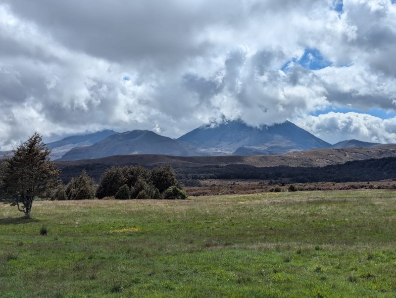
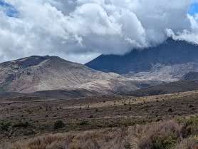
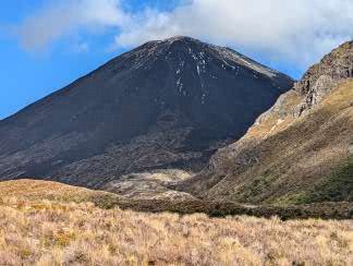
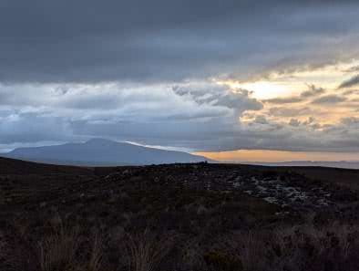
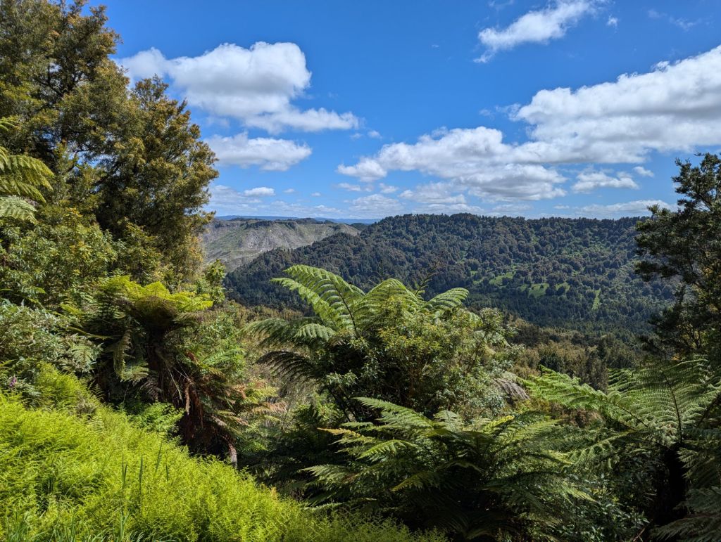
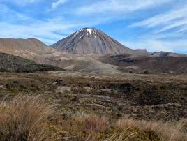
The morning walk was a gradual climb up to Tama saddle through low brush. On our right the mighty Mount Ngarahoe, walking around the southern aspect this time, still black and brooding even in the sunshine.  On our left the snowy Mount Ruapehu, gleaming white.  Awesome, beautiful, stunning – we have used all these adjectives many times already and need some new ones. As we set off we saw a lone walker ahead of us (going faster than us and so not for long) but then we saw no one else for the entire morning.  It felt wild and tame at the same time in this weather; much of the time I guess it feels wild and wilder as walkers are immersed in cloud.

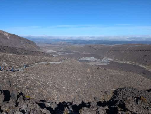
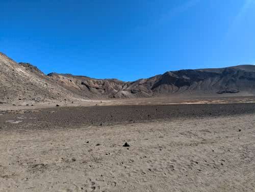
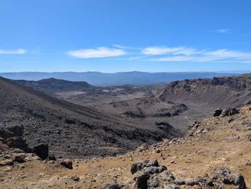
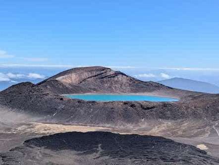
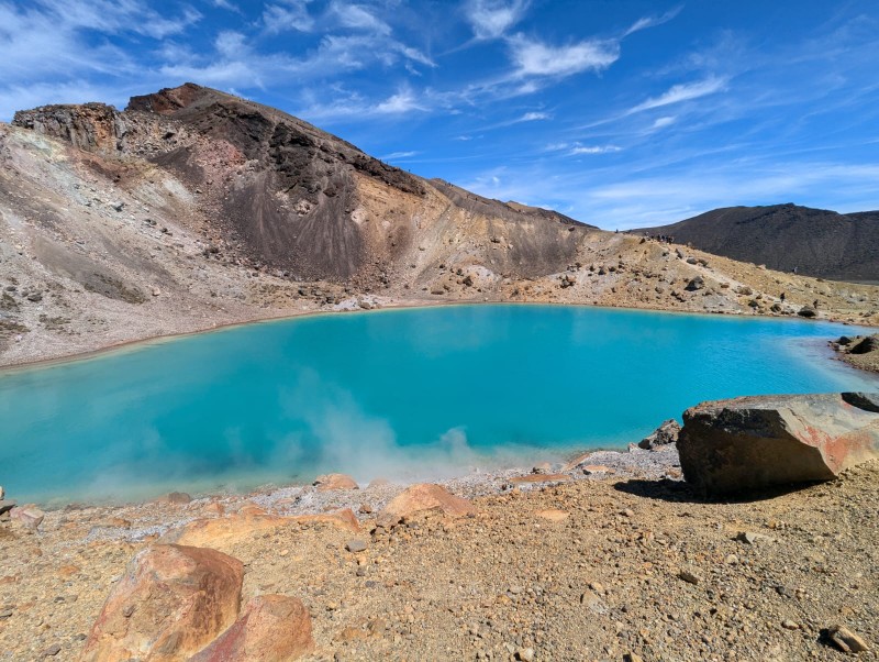
We were walking really well and we seemed to reach the saddle in no time.  We almost wanted to walk slower to make the walk last longer.  There was a small side route which took just 10 minutes to the overlook Lower Tama lake;  a glistening blue backed by jagged rocking cliffs.

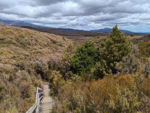
We decided not to add on extra hour there and back to the Upper Lake as we knew we had a way to go to reach Whakapapa village (Wh is pronounced Ph/Fh we later found out). We thought, after reaching the summit, it would be a gradual down hill all the way, similar to the way up.  But it undulated up and down with short but steep gradients.  Suddenly we began to feel the tiredness in our legs; largely psychological when you have to go uphill when you were expecting to go down. However over the last brow we could see the village ahead and a steady path down. We also suddenly started to see lots of people. 

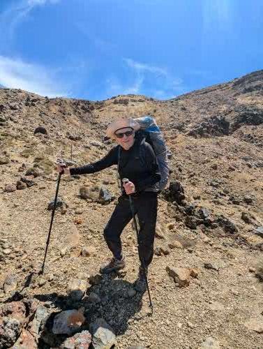
The walk up the Tama lakes is a relatively easy day walk from the village, and more so at the Taranaki falls which is a 2 hour circular walk. We felt somewhat dishevelled, and probably a bit smelly, as we lumbered down the hill tortoise like with our worldly belongings on our back, as other skipped up fresh with gleaming white trainers.  Everyone had a cheery smile and some even an admiring (or possibly pitying) look.  No one quite said that we should not have left the old folks home but it was perhaps well hidden on their faces!

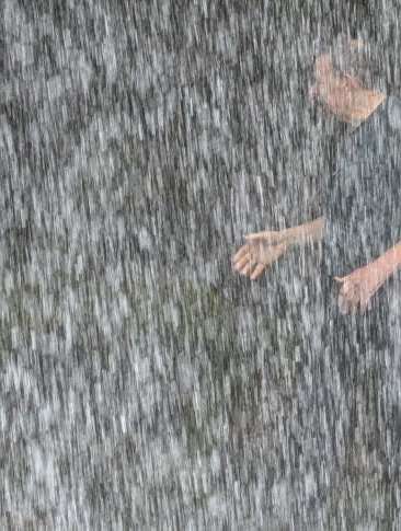
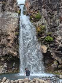
The Taranaki Falls was our last ‘feature’ stop. An impressive gush of water over a cliff, dropping about 30m to a pool before running off down the hill. David of course could not resist walking round the back of the falls and dipping his head into the water.  He came out looking rather damp but gained the admiration of a group of lads who proceeded to follow him – and got a lot wetter than he did!

The last hour of any walk, whether 4 hours or 4 days, always seems a drag, and so did this one as we reluctantly reached the village and could not extend the walk any further as we handed in our emergency beacon (unused!) at the Visitor Centre.  Then we had an excellent coffee and pie at the coffee-cart as we looked back up at the mountain and the route we had walked. Let’s be honest – we felt a tiny bit proud of our achievement.  It was not just walking around the TNC with full packs, carrying our own food, camping and tramping all the way.  It was that we had enjoyed ourselves so much.  We were left to wonder what the experience would have been like in fog, wind and rain, with endless climbing and nothing to see at the top apart from more cloud.  We were stunningly lucky and will have days ahead when the weather gods are not blessing us, but for now we were basking in the sunlight as we took a final look back at these wonderful mountains.

Day 3.  Tongariro Northern Circuit.

(Bernie) Unlike our neighbour (a professional travel writer) we managed a good sleep in spite of the howling gale rattling the tent all night (not smug at all of course). However we did not see the dawn as I had no intention of opening the tent flap in the gale! By 6am though the call of nature dragged me out of the sleeping bag and into the morning. In the hut everyone was up and about and you could not hear or feel the wind! Luckily the Department of Conservation instruction that campers should NOT be permitted to use the hut facilities  was no applied in practice (at least not here, at this time of the season. Others tell that it is strictly enforced elsewhere).  We could therefore brew our coffee and our porridge, and eat our breakfast in relative comfort.

Taking down the tent involved a complicated dance with the 2 of us unpegging and clutching and folding down the tent before it was ripped from our hands.  We managed to avoid any part of the tent blowing over the ridge and down the valley (chasing a tent sheet in the strong wind would have been a real challenge) and hurriedly brought everything down from the ridge to the hut where our belongings were strewn out ready for repacking.  The only thing missing was the bag to our platypus water filter.  David went back up the ridge and unbeleivably the very small and lightweight bag was caught in a bush and he brought it back triumphant.  We were complete!

We only had a short day today so we took out time and we ambled off relatively late at around 9am.  By this point the wind had decided to die down somewhat. We were on the dry side of the mountain, walking across arid desert-like conditions, with multi-coloured rocks that showed their volcanic past.  Now we were walking round the opposite (i.e. southeast) side of the volcano – a looming presence above us still and almost totally free of cloud in the blue sky. Although the forecast was for rain by lunchtime the skies remained bright and sunny.  Our legs were tired from the previous long day and all the climbing but we were moving well and made good progress.

For reasons unbeknown to us, but presumably because it had missed previous lava flows, the scrubland which was devoid of vegetation ended and we reached a pretty wooded area.  Crossing a fairly large river (on a bridge, not wading!) there was a sharp but extended climb through the trees.  When we emerged out of the trees onto the ridge, we were greeted with dramatic new views of a snowy Mount Ruapehu.  It was then a gentle amble down to the hut, our destination for the day, just a 3 hour walk.

Arriving at lunchtime and setting up tent was peaceful and slow.  We camped in a clearing in the bush, just beside a river.  It was quite cool in the shade but hot in the sun – a huge difference. 

We then walked out to a set of mountain springs that emerge from the hillside, with water that has taken hundreds of years to percolate through the rock and then make its way back up to be extruded.  It was a special place – and supposedly a place that two blue ducks had made their home.  That may well have been true but the ducks were off somewhere else for the day when we visited.  However it was peaceful and beautiful. 

Back to the hut for more chat, food and chat.  One of the features of these walks is that one picks up a group of people who all follow the same trail at the same place – so we caught up with Mary and Polly and Cat and Brandon, as we had the previous evening.  Another talk from a warden – not totally inspiring and mostly about her life as a warden which was sort of interesting, but honestly not that interesting.  A guide to the volcanic history or the local wildlife would have been gripping – but we got what we were given.

Then back to our books and sleeping bags.  After just 3 days on the trail the enjoyable rhythm was settling in – just as when we are cycling.  It was strange to think that tomorrow we would be back in civilisation (of sorts that is).

Day 2. Tongariro Northern Circuit.

(Bernie) Most of yesterday the mountain tops had been wreathed in cloud but during the evening the clouds cleared revealing our first view of the conical mountain Ngaruhoe and the snowy peak of Ruapehu. Clear skies meant a chilly night but we were snug in our sleeping bags and slept well.  We woke at 6am to beautiful clear skies, made coffee, cooked up our porridge and were set to go by 7.15.

The first part of the day overlaps with the famous Tongariro Alpine Crossing – a day walk rightly billed as one of the best day walks in the world. It is an end to end walk so shuttle buses collect walkers from the end and deliver them to a car park just below the Mangetepopo hut.  We were told the first shuttle buses drop walkers off at the start carpark, which is half an or so down from the campsite; so if you want to avoid the crowds you needed to leave at either 6am or 10am.  We didn’t want to do either of those so decided just to go with the flow. Although there were plenty of people on the track it did not feel oppressive and the landscape was so awesome (taking the literal meaning of the word) nothing could detract from the day. It was one of the best day’s walking I have ever done.

The first part of the day took us up a gentle valley with the steep climb out of the valley ahead of us.  We had our first good views of the amazing Ngaruhoe volcano as we crossed the old, and not so old, lava fields.  Signs warned us that we were entering an active volcanic area.  The volcanos in Tongariro erupt with reasonable regularity – luckily mostly small eruptions are limited to steam or ash, although these can still do a good deal of damage.  The last eruption experienced on the track was in the 1970’s and described as a very near miss for a walking group – so not so very long ago. Huge boulders told of the massive eruptions of times past.

At the base of the climb further signs gave warnings that people should turn back if the weather looked bad or they were feeling unfit.  We learned that about two people a week are airlifted off the track during the summer season. However, today the skies were clear blue, the air was still and we were feeling invigorated; so we started the combination of steps and steeper path up to the first crater. We got into a steady pace and although not as fast as the youngsters overtaking us, we were not as slow as others and felt rather smug that we were making our way up with our heavy packs while others had day packs (small pleasures, ridiculous of course!).  The ever expanding, stunning views begged for frequent stops to gape in any case and to capture in photos.

Suddenly we were stepping into the South Crater with a pancake flat base.  We stopped for a break overlooking a smaller side crater with views up the red and black side of the volcano.  A climb out of the far side of the crater to the Mangatepopo saddle opened up the views on the other side to the Oturere valley.

  A last fairly steep climb took us to the highest point of the walk (1867m) with breathtaking views over the Red Crater, Tongariro mountain, the Blue Lake and Emerald lakes with their steaming fumeroles.  I hope the photos do it justice.

 We realised how lucky we were when we met the guide we were chatting to at the campsite the previous evening.  He guides teenagers on their  Duke of Edinburgh hikes (yes, DofE is in NZ) and had done the trail numerous times.  He said he had never seen it so good – usually the top is on cloud. A ranger later described the weather as “one in a hundred day weather”. The summits of the mountains are sacred to the Maori (you are therefore not allowed to climb to the summits); for some reason the Maori gods were smiling on us today.

(David) I get the easier bit to write about – going down!  But the first stretch was quite tricky, as we descended a steep shoulder with drops on either side.  Underfoot it was moving sand and small rocks, and a bit like descending a scree with very small stones.  Bernie took it easy and at one point stopped to allow a woman behind her to pass – but was told “No – I am following you – you are doing this descent so elegantly!”.   Wholly unsurprisingly, no one complimented me on my descending technique as I staggered down trying not too lose my footing – when many did.  No one tumbled off the sides – at least as far as we could see. 

We stopped at the bottom by the fumeroles (wispy volcanic smoke coming from ground indicating activity just below the surface) in a small gap which was not overwhelmed by the stench of rotting eggs for our lunch – Ryvita, peanut butter and cheese!  Whilst I accept this combination is not offered in the best restaurants, it was high calorie and delicious after 4 hours walking.  Mary (one half of the Tasmanian couple joined us) whilst her partner, Polly, mooched around the volcanoes.  They have a daughter who teaches geography in a tough school in Tassie, and were under strict instructions to take photos to bring life to her classes.

The paths split at this point – with the day packers on the TAC heading north to the end of their walk at Ketetahi car park and the TNC multi-day walkers heading towards Oturere hut.  Suddenly the valley was deserted as we climbed down a section called the dragon’s tail.  The Oturere Valley is high altitude desert with stunning rock formations.  For those who have seen the Lords of the Rings films, this is the set for Mordor.  By this point we were a tad tired, but met a jolly face coming the other way with a spade, clearing the track.  This was Sally the Oturere hut ranger who told us we only had an hour to go, and all would be well!  She was roughly right – it was about an hour but it stretched out as tiredness set in.  But soon we went over a small ridge and there was the hut, nestling just below a ridge.

Sally had advised us to camp up on the ridge as she said the dawn was lovely from there.  90% of the time this is good advice; we were in the 10% when wiser heads would have pitched below the ridge line.  But, in the calm of the afternoon, there seemed no reason not to take her advice.

Once the tent was pitched and a brew revived us, we ambled over to a stream for a wash and paddle.  Mary had said she had “wallowed” in the water but she is clearly made of sterner stuff than me as I managed it up to my knees before screaming from the cold.  But it did leave us cleaner than we had been for 48 hours.

A windy night!

Supper, reading, chat, brew, reading, more chat, funny stories, and early bed.  That is the way of life on a trek and it is super enjoyable.  I was stuck into a crappy book, loved the scenery and wished it could go on for ever. However, as the evening drew on, the wind got up and the lack of wisdom of our chosen campsite became clear.  It was dry but blew a gale all night, with the sound of the wind trying to keep us awake – mainly unsuccessfully I can report.  However the only reason the tent did not blow away down the valley was that it was weighed down our bodies!  At one stage I got up to see if the guy ropes were holding – they were – and then went back to sleep.  The woman in the next tent was on her own and claimed not to have slept a wink all night!

Day 1:  Tongariro Northern Circuit

(David) Now I know that this is a cycling blog – but this next few entries have no wheels and only describe a walk – or a “tramp” to give our activity its local name here in NZ.  For those who are only interested in cycling, I suggest you “look away now”.  For the rest, this is a description of one of the NZ “Great Walks”, the Tongariro Northern Circuit, also known as the “TNC”. 

The TNC is a walk in the Tongariro National Park.  It takes up to 4 days and goes around the conical Mount Nguruhoe (2287m), a classic volcano which looks like a mountain that a child would draw – straight sides and a snow covered top.  The smaller mountain, Mount Tongariro (1967m) is north of Mount Nguruhoe, and the walk crosses the saddle between the two mountains. On the other side of the valley is the much higher Mount Ruapehu (2797m) which is longer and has an extensive snow covering at this time of year.

We drove from our accommodation in Turangi (having failed to find time to go fishing in a world fly fishing mecca) to the strangely named “Whakapapa” village to start the walk.  We later learned that it was pronounced “Fu-whack-a-pappa”. The road took us gradually up to the village which is at about 1150m.  The landscape was high altitude moorland, dominated by the two volcanos to the north, Nguruhoe and Tongariro and the Mount Ruapehue (2797m) range to the south, where there is extensive skiing in the winter.

There are huts along this walk but they were all fully booked before we got our act together and so camping was the only option.  Overall, this was better for us as it meant we got a good night’s sleep most nights, as opposed to the hit and miss of a night in a shared hut.  Having sorted out renting a locator beacon (being either intent on being as safe as possible or as pessimistic as it goes) we put on our packs and started walking.  A word about our packs – and thanks to our great friends Gill and Peter who provided advice and encouragement from their many years of trekking.  We got lightweight rucksacks before the trip, good poles and a few other items such as a gas burner, but most of the kit was the same as we have used for cycle touring.  The difference was we also packed freeze dried meals and other food for 5 days – 4 days plus a spare.  The packs were heavy but not ridiculously so; probably about 14g for David and a bit less for Bernie.  

We started our trek in the dry, but with cloud over the top of Mount Nguruhoe.  The terrain was marsh/mud which went up and down across numerous streams that flowed down from the mountains to our right.  Heather was introduced to this area to provide cover for grouse in the early C20th, but was a disaster as it wiped out the native species.  Grouse never survived and so the original plan of turning the slopes into Scottish style grouse shooting never occurred.  But heather spread at pace, with local fauna declining.  The invasive heather is now a pest which the NZ Department of Conservation is attempting to remove – but it is a massive job as it has spread over vast areas. 

The walk was steady rather than dramatic.  There were a few others on the track – some overtook us and others came the other way.  We could tell instantly if someone was a day walker – small pack – or a multi-day walker – big pack.  The day walkers were faster (of course) and most of the multi-day walkers were faster than us (again of course).  Lots of jolly greetings along the way.  As we walked, the shape of the mountains changed – but far more slowly than on a bike.  Gradually the top of Mount Nguruhoe cleared of cloud, revealing its classic shape, and we got to see the saddle we would have to climb tomorrow.

After 3 hours of sliding along muddy tracks we reached the Mangetepopo Hut at about 3pm, and found a place to set up our tent.  The huts are hugely sociable places and we chatted to other walkers, all of whom had come to the hut under their own steam.  There was no warden, no electricity and no hassle – everyone just getting on with things.  We chatted to a couple from Tasmania who were about our age, a young couple from Boston, USA who were on a delayed honeymoon having negotiated 4 weeks holiday (amazing in a US context) and lots of New Zealanders.

Our first experiment with freeze dried meals was about 75% successful – we will get better with them – but it was tasty.  By 8pm we were in our sleeping bags as the temperature began to fall and the light faded.  This was both remote and not remote.  It was remote in the sense that there were no roads, we were in a tent and felt tired from a decent walk; but it was also not remote in the sense that another tent was pitched very close to ours and we were on a fixed and very popular walking route. That seemed about the right balance to start getting used to the experience of tramping.  If it goes well, we could explore more remote settings at a later date.  For now, this was as good as it gets.

Timber Trail Day 2.


We woke well before the alarm went off at 6, as we were surrounded by a cacophony of birds. I opened the tent flap to see a cluster of quails hopping around – soon dispersed as I came lumbering out. The ground was wet but we were dry and it was almost sunny.

Oh it had been so tempting to ask for a room at the lodge last night with it’s lovely lounge, wood burner and hot showers but as the only people in this huge campsite in the early morning it was quite magical. I had been exhausted last night but felt invigorated.

Our routine of packing up camp fell back into place, fitting in 2 cups of coffee and honey flavoured porridge mixed with last night’s crumble – delicious. We had our packs back at the lodge by 8, ready to be taken down to the end of the trail and we were on our bikes and on our way again.

The trail passed through the bush and amazing forest.  The only people to be seen were the handful of bikers who had also started the trail yesterday, leapfrogging each other as we rested at different places – although the ebikers eventually were way ahead of us.  We were in no hurry, wanting to savour the environment, especially as the sun came out.  They say there is something different about the blue of the sky and the green of the land in New Zealand and it certainly seemed that way.  Maybe it’s the lack of ozone – an odd quirk of the climate catastrophe. 

I am not a mountain biker but was really enjoying the off road cycling.  Sometimes the trail was a narrow weaving track and more often today, a wider trail following the tramway where the logs were hauled out of the forest. It must have been lucrative business to justify the engineering blasting cuttings through rock and another series of amazing bridges across deep chasms to rivers below.  The old wooden bridges are now replaced with modern suspension bridges.  Not a fan of heights I kept by eyes ahead and peddled across them with a fixed stare – allowing myself more leisurely looks when safely the other side.

There was less climbing today, and generally the route was less steep, but my legs were still tired from the previous day. At the 70km mark though we started a glorious gradual descent.  I was more confident on the mountain bike and felt I could let the bike go. The forest gradually opened out into a wider valley with the last few Kms through meadows of grass, foxgloves and yellow broom.

Back at the car, our packs had arrived and we were off to stay in Turangi an hour or so away to rest up before our next adventure.  I was totally exhausted and was in bed by 8 but a brilliant ride and fantastic introduction to the amazing outdoors offered in New Zealand.


Timber Trail Day 1:  New Zealand

It seems a very long time since I last tapped away at a keyboard after a day on the bike, recording our travels and trying to make sense of the world.  A small explainer – I was fit and well in March last year as we left Vietnam and by January this year I could not walk more than 200m without huge difficulty.  It seems as if – for reasons that are entirely mysterious –  the arteries in my heart clogged up and I was getting less and less blood flow around the body including to my head.  The wonderful cardiology team at Wolverhampton sorted me out with a quadruple bypass in late January. 

Then it was a period of slow recovery, and gradually getting my fitness back.  By the summer I was back to walking and climbing mountains and a week ago we left for New Zealand to escape the UK winter and put my recovery to the test.  So that is why we found ourselves cycling mountain bikes along the Timber Trail in the middle of the North Island of New Zealand.

The Timber trail is an 84km long off-road cycle and walking route that was created by the NZ Department of Conservation and teams of volunteers between 2009 and 2013, when it was opened.  It is located in Pureora Forest Park and has 35 bridges along its route.  This is former logging country and the southern half of the trail follows a former tramway that was used to pull logs out of the forest called the Ellis and Burnand Tramway. 

We left our B & B early and met up at the end of the trail south of Ongarue where we picked up hire bikes.  Bernie’s brother had been kind enough to offer us their bikes but cycling around urban Wellington and cycling across the bush are wholly different and we decided to fork out for bikes that stood a better chance of withstanding the rigours of the trail.

A minibus took 4 of us from Ongarue to the start of the trail at Pureora.  The bus ambled through farmland with forest up on our right.  This is tough sheep and cattle country, as is so much of rural New Zealand.  It was overcast and rain threatened.  We had left the start of winter in the UK and it was spring here but definitely not yet summer. 

Our group included Anja from Holland, who was travelling on her own and a NZ man who was helping his brother and a friend who were walking the Te Araroa, the 3,012km walk from one end of Aotearoa New Zealand, to give the country its full name, to the other. 

Jackets on we started out on the trail – and that is what it was.  No roads here and just a meandering trail through the bush.  Tall podocarp trees flanked the trail with birds calling out to warn others of our presence, or maybe just calling out because they can.  There were occasional signs that is was an area of forest operations.  The peak of forestry was between the second world war and the 1990s, delivering timber to build houses throughout the country’s post war economic development. 

We were not alone on the trail, but it was never crowded.  Occasional groups of ebikers would (of course) pass us as they glided (seemingly) effortlessly along.  Most appeared to be NZ nationals but there were the inevitable Dutch riders.  Wherever we go in the world we meet Dutch cyclists.  The combination of cycling and travelling seems part of their national psyche.

This route is well marked and we were only aiming to do 39km on the first day.  But mountain biking is not like road cycling, there is far more rolling resistance, especially in the mud, and the trail went up to 917m at its highest point.  We reached the high point after 14km, and had the pleasure of cycling across the 115m wide Bog Creek suspension bridge, with its spectacular views over the forest below.

The track merged into an old logging road and gradually descended, but with some more steep climbs.  By this point we had got used to the foibles of the bikes and Bernie’s confidence was growing.  The bush was dense throughout the day and the overcast weather limited the views.  There were numerous signboards along the way pointing out local fauna, flora or explaining how the forest operated as a working forest. The boards were clearly put up when the trail was new and, of course, the forest changes and develops all the time.  That meant that some of the “views” were obscured by vegetation but that is a good thing as it shows the forest recovering from being plundered.

 Eventually we reached the end point of the day, Piropiro.  There is a lodge here where most trail riders were staying but we had elected to camp.  Part of the transport service we signed up to dropped our rucksacks at the Lodge and so we stored the bikes and walked the 500m down to the “campsite”.  This was a field with a pit toilet and access to river water.  The Lodge was not built until several years after the trail opened and so, at that stage, camping was the only option.  Now an expensive night awaits those who prefer not  to spend the night under canvass; which we discovered was almost everyone apart from us.  There was a second “glamping” option at Epic Campsite but we wanted to test out our camping gear before going on a 4 day trek and so opted for the basic campsite.

We got the tent up in the dry and then the heavens opened.  Sitting inside the tent with hail hitting the roof, we wondered about the wisdom of our choice but it was all fine when the storm abated.  We ambled up to the Lodge for a beer after a home cooked supper, but found that they could only sell alcohol to residents!  Ginger beer in front of  log fire was an excellent alternative. The residents – many of whom we had exchanged greetings with on the trail were just finishing their evening meal.  We fell in to chatting with a South African couple who were finding the trail hard, even on ebikes.  They expressed “surprise” we were camping and, a few minutes later the woman turned to us and said in a conspiratorial whisper that if her husband ever asked her to do what we were doing, she had told him that he would need to find a new wife!  It was unclear whether he took this as a threat or an opportunity.

The Lodge staff were really friendly even though we were not staying there, and they even offered us some left over apple crumble; and then, as we were leaving, the cook pressed us to take more apple crumble. Over catering has its benefits.   That turned into a marvellous breakfast but, for that detail, you will have to read on to tomorrow.